At midnight, people around the world will celebrate the changing of the New Year from 2011 to 2012. And at the infamous hour, there is no drink quite like Champagne to help celebrate.
I read an interesting article in the Wall Street Journal about Champagne, and it touched a bit on the history. The drink is specific to a region in France; for this reason, Champagne from other areas are not considered “true” Champagne. In essence it is just a sparkling, carbonated wine.
Dom Perignon, a Monk, is said to have invented the drink in the mid 17th Century. In the beginning the drink was red, but today champagne is traditionally white.
A Year in Review
Last year I started a tradition by selecting some newsworthy events I thought would be historical. 2011 has certainly been a colorful year; continuing the tradition, here are some events I believe have made history in 2011.
January 2011- Present- The Arab Spring- Beginning in Tunisia, and spreading through the region via social media, people in the Middle East began rebelling against oppressive dictators and protesting for change.
Some important dates:
Jan. 14- Ben Ali flees Tunesia
Jan. 23- Protests in Yemen
Jan. 25- Mass protests against Mubarik begin in Egypt
Jan 28- Protestors gather and demand change in Jordan
Feb. 11- Mubarik resigns
Feb. 16- Protest erupt in Libya
Feb. 25- “Day of Rage” in which many protest across the region
March 19- Syrians begin to protest
Oct. 20- Gaddafi killed
March 11, 2011- The Japanese earthquake- At roughly 2:46 p.m. a terrible earthquake struck the northern part of Japan. Aftershock caused a deadly tsunami, destroying parts of the country, and killing thousands. The event left chaos and destruction in its wake, but unlike many naturally disasters the people of Japan banded together, helping those affected rebuild their lives.
April 29, 2011- The Royal Wedding- Women state side celebrated the union of Prince William and Kate Middleton, getting up as early as 2 a.m. to watch the ceremony live. Personally, I slept and watched reruns.
Mat 1, 2011- Osama Bin Laden is killed by U.S. military personnel, almost ten years after the September 11 attacks on the World Trade Center.
October 5, 2011- Steve Jobs, co-founder and CEO of Apple, dies from cancer. Since his death, the man has been controversial, but regardless his ideas and marketing strategies have changed the face of technology.
October 20, 2011- Libyan dictator Muammar Gaddafi is killed. The brutal footage of his death was leaked online.
December 19, 2011- Kim Jung Il, dictator of North Korea dies.
December 2011- The End of the Iraq War. Troops are in the process of being withdrawn from the country, ending a way started ten years ago.
It is amazing to think it is the end of another year. 2011 has held many personal ups and downs for me, but overall I think I can look back and think fondly on the year. I do know 2012 holds promise of greatness, and promise of my history reported.
Thank you all for reading, and wishing you a Happy New Year!
Saturday, December 31, 2011
Wednesday, December 21, 2011
Winter Solstice

Synchronization: in history, a term used to describe when religious practices are recycled in newer religions, making adoption of the newer religion easier to adopt.
You are probably wondering why I begin my blog with a vocabulary lesson, especially considering my track record with spelling (yes, I am fully aware). But keep this idea in the back of your mind as you read on; I’ll come back it at the end.
Solstice comes from two Latin words: sol (sun) and sistere (to stand), meaning the sun has reached the northernmost ecliptic, and appears to stand still.
For centuries, and across cultures, the winter solstice has been celebrated. In my Medieval England class I learned a bit about the winter solstice, and how Christianity adopted the holiday. But I was curious about the history of the festival.
The winter solstice is rooted in many ancient religions. Almost every one of them celebrated this important day as a seasonal milestone. Because this is the shortest day of the year, many saw this day as a day of fertility; the days only do get longer after this pint. Another way to think about the festival is that if the sun has been diminishing, it would make sense to appease the Gods so they will bring the sunlight back.
In Scandonavia, the festival was called Yule. The Druids began the tradition of the Yule log; it was lit to banish evil spirits, defeat darkness and bring good luck for the coming year. The logs would be lit for twelve days, before another ceremony was held to extinguish the fire. Sprigs of holly and ivy were brought into the home to celebrate the solstice. Both plants are evergreens, so they signify the eternal nature of the sun.
The Chinese people gave this holiday a great importance, saying it was as important as the Spring Festival. During the Zhou Dynasty it was known as the New Year. During the Tang and Song Dynasties it was on the winter solstice that heaven and ancestor worship was performed.
In the Persian and Egyptian cultures the start of the solar year was marked to celebrate the victory of light over darkness; thus it would make sense to celebrate during this time of year when the sun once again come to prominence. The Persians adopted their festival of Daygan from the Babylonians. The celebration, called Shab-e yalda, included feasts, fires being burnt all night and a temporary subversion of order where masters and servants would switch roles. This would allow chaos to reign for one day before order was restored and succeed at the end of the festival.
The ancient Romans celebrated Saturnalia, which was one of the most important celebrations on their calendar. While it was originally a one-day celebration, it grew to last from three to seven days. People celebrated with drinking gift-giving, bonfires, candles and role reversals for slaves and masters; yes, this practice was adopted from the Persian practice.
Also important to Persian celebration of the winter solstice was Mithra, the Sun God. The winter solstice was his birthday.
So now back to my vocabulary lesson at the beginning of this blog. The similarities in how different cultures celebrated the winter solstice would suggest that cultures took traditions and repurposed them for their own holidays.
Now, winter solstice falls pretty close to Christmas doesn’t it? Think this is a coincidence?
It is not.
Around the time that Christianity began to spread, Mithraism (the worship of Mithra) has spread from Persia into the west. The religion was popular among the Roman army, and some scholars would even argue that Mithraism was a rival religion to Christianity. Around 4 C.E. miscalculations in leap years etc placed the birthday of Mithra at December 25.
Christians took a pagan holiday, already in practice, and repurposed it to make it easier for people to practice Christianity. Prior to 4 C.E. Christ’s birth was celebrated around January 6; the popularity of Mithra made the church rethink the holiday, and change the date to December 25.
Accepting a new religion is much easier when the holiday adopts old traditions. This is exactly what the Christian Church did with Christmas. If you truly read the Bible, you’ll see that it was actually summer when the birth story takes place, not winter.
Tonight is a snowy night in Colorado, perfect for ushering in the winter solstice. I hope everyone has a bright holiday season, regardless of the holiday you celebrate, or the traditions you keep. And remember, as always, Happy History!
Sunday, December 11, 2011
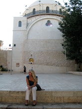
Jerusalem Part 4: Al-Aqsa Mosque

But what about the Al-Aqsa Mosque?
The Al-Aqsa Mosque is located along the southern edge of the temple mound.
This summer I was fortunate to work with Dan (no last name’s allowed), who is a CSU graduate also. He actually helped inspire me to persue going on the dig; while in my Ancient Israel class he came and spoke to us. Even better, he was my square supervisor at the site, and we recently presented together for the Ancient Israel class our professor is teaching this semester.
The background information aside, Dan had taken a crusades class while at CSU, and he told about an attack the crusaders waged against the Muslims, an attack that did not end at the doors of the Al-Aqsa Mosque, but that continued inside and included the slaughter of innocent women and children. These moments in our past are really unfortunate to hear about, but this fact stood out in my mind and is what inspired me to really look into the background of this site.
One fact: did you know it is this Mosque, not the Dome of the Rock, that is the third most holy site in the Islam religion?


Today, Mecca is the direction of prayer, but for 16 months following the Prophet’s journey, Jerusalem was the direction of prayer. And during the Prophet’s life, he instructed Muslims not only to visit the Mosque in Mecca, but also the “furthest mosque” from them, or the one in Jerusalem.
Al-Aqsa Mosque is the second oldest Mosque, and the third most important Mosque in Islam.
I did look up Crusade information, and found the Jews were burned alive in their synagogue at this same time. A gold cross was placed on top of the Dome of the Rock, and it was renamed Templum Domini, while the Al Aqsa Mosque became the Temple Solomonis. The Al Aqsa Mosque was subdivided to serve as a palace for the Knights Templar.
I’m glad I did a bit more research on the site I was fortunate enough to see! Hop everyone enjoyed reading, and happy history all!
Monday, December 5, 2011
Hot Chocolate
Colorado has an average of 300 days of sunshine every year; so it’s usually not too unbearable during the winter here. However, we have an Arctic front coming through this week, so the high today was somewhere around 10 degrees, and the low is in the negatives tonight.
That is why when I saw the link to this NPR article about Hot Chocolate I became particularly interested and inspired; there is nothing quite like a cup of hot chocolate on a cold day after all.
So what is the history of hot chocolate? On this cold night I think I’ll make myself a cup, curl up next to my computer and answer that very question.
Archaeological evidence suggests chocolate was being cultivated some 4,000 years ago. In the Mayan culture cocoa pods symbolized life and fertility, and was used in religious rituals and was considered the food of the gods. The Aztecs believed wisdom and power came from eating the fruit of the cocoa tree. It was even used for currency in the culture.
For most of its history chocolate was consumed in drink form; it wasn’t until the late 1800s that chocolate bars became fashionable. I do have an earlier blog about chocolate, visit it here.
It is said George Washington drank hot chocolate with his breakfast. The recipe included grated chocolate and sugar mixed into a cup of warm water, milk or even brandy (for a real kick). New world flavors like chili powder, vanilla and allspice created a complex concoction, making it richer and sweeter than the hot chocolate of today.
Usually Europeans did not like to experiment with the New World foods, but chocolate was the exception. Who can’t love chocolate? In 18th Century Europe chocolate was a status symbol a treat of the rich and royals. But in the United States everyone, rich and poor, enjoyed chocolate alike. This is probably because the chocolate was located much closer geographically to the United States that Europe.
Chocolate was also valued as a high-energy food in Colonial America, one that didn’t spoil.
And so is the history of hot chocolate. Hope everyone finds their own way to survive the cold weather this winter, and happy history!
Wednesday, November 30, 2011
Jerusalem Part 3: The Dome

On Sunday mornings, tourists are allowed to visit the Dome of the Rock, on what was once known as the Temple Mound (because it was once the location of the Jewish Temple).
I went back to Jerusalem with my group from the archaeological site. One of the people traveling with us suggested going to see the Dome of the Rock, and I was instantly all for going. I have always wanted to travel up and see the site, not only the Dome of the Rock but also the Al-Aqsa Mosque and the scenery up there.
So what makes this spot holy? According to Jewish literature, it was the rock here where Abraham placed his son Isaac to sacrifice. It is also believed this is the site of the Holy of Holies, and the first and second temple.
The Dome of the Rock is the most Holy site for the Islamic religion in Jerusalem. It was built from 688 to 691 CE by the Umayyad Caliph Abd al-Malik and was not intended to be a mosque, but a shrine for pilgrims to commemorate Mohammad’s ascension into heaven after his night journey to Jerusalem. This is when God told him to pray five times a day.
Another idea is this site was built a site to compete with the Christian Churches, and to be a symbolic statement to Jews and Christians of the superiority of the new faith of Islam.
The Arabic inscription around the octagonal part of the Dome of the Rock are versus from the Qur’an. Just below the gold dome (which is gold leaf today, donated by King Hussein of Jordan) are tiles featuring Arabic inscriptions telling of the Night Journey of Mohammad.


The Dome of the Rock sits directly above the most Holy place for the Jewish Religion, and commemorates a very important moment for the Islamic Religion. I don’t want to get into the controversy of this site, because there is a lot of controversy. If you are able to put it all aside and see the site for what it is, you are certainly in for a treat.
The site is breathtaking. Up close, you can see the detailed decoration on the outside. It is ornate, detailed and breathtaking. Each time I looked at the site I felt like I was seeing something new.
I wish I could have looked inside; visitors are no longer allowed to go visit the inside, which was something I was unhappy about. The only glimpse I saw was through a small crack between some doors, but what I saw rivaled the outside. This website has some fantastic images of the inside of the Dome of the Rock

I am so glad I took the time to visit this site. It is spectacular, and is a place I wanted to see up close. The Dome of the Rock is probably one of the most iconic images in Jerusalem; the gold dome is seen through the city. And personally, I was glad I could see the holy sites of all three religions. It was a truly meaningful experience.

Thursday, October 20, 2011
The Cliffs

One week after posting on September 11 my computer hard drive crashed. I had some things backed up (most of my pictures from Israel), but really not much in the way of documents.
This includes my blog.
Thankfully, I only lost one post unpublished. So little by little, I’ve been copying and pasting all of my old posts to a new Word Document. Did I ever mention I had over 70 pages of posts compiled over my nearly two years of blogging? I was hoping to recover my old files, but that is still a working process. The plus of the situation is how much fun it has been to look at my old posts. This is actually a great opportunity for me, despite the bad that comes with losing files.
In the mean time, I’ve been thinking about Arbel often. Located west of the Sea of Galilee, this site was one of my favorite stops in retrospect. I had a picture snapped of me (which I did stage a bit) looking at the amazing view from the top of the cliffs. Every time I feel frustrated, I just think back to that picture, and it helps me get through it.

As with most places in Israel, Arbel does have a history. This story comes from the time of King Herod, and is simply fantastic. I quote the story by Josephus, with all its flair and possible additions. Enjoy!
***
“Herod reached Sepphoris in a snow storm. From there he then sent out a troop of cavalry and three companies of foot soldiers against some of his political opponents hiding in the caves near Arbel.
“Herod Had made up his mind to put an end to their resistance. After forty days, Herod came with his entire army. After a brief military setback, Herod rallied his troops and routed the people as far as the Jordan river. Thus, Herod secured Galilee for himself, except for those holding out in the cliffs of Arbel. Herod began to hasten his assault.
“Now their caves were altogether rugged, having the entrances half-way up the sheer cliffs, and being surrounded by sharp rocks. In such dens did they lurk with all their people. Thereupon, Herod, whose men were unable either to climb up from below or creep upon them from above because of the sheer steepness of the cliffs, had baskets built and lowered them with chains from the summit.
“The baskets were filled with armed men with grappling hooks, which were to be used to pull the resisters from the caves to their death. The baskets being lowered proved to be a risky tactic due to the immense depth that lay below them, although the soldiers in the baskets had everything they needed. But when the baskets were let down, none of the men near the mouth of the caves dared to come forward. Instead, they remained quiet out of fear.
“However, one of Herod’s soldiers, irritated at the delay being caused by those in the caves, girded on this sword, and holding on with both hands to the chain below the basket, lowered himself to the entrance of a cave. And when he came opposite an entrance, he first drove back with his javelin those that were at the entrance, then with his grappling hook he drew his opponents toward him and pushed them over the precipice.
“After this, he attached those within and slaughtered many of them. He then re-entered the basket and rested.
“Then fear seized the others as they heard the shrieking, and they despaired of their lives. As night fell, all actions ceased and Herod offered those in the caves an opportunity to surrender, and many chose to do so. The next morning the same method of attack resumed and the soldiers in the baskets fell upon them still more fiercely. Fighting at the cave entrances, the soldier threw flaming fire into the caves and so the caves, which had much wood in them, were set afire.
“Now there was an old man shut up in on e of the caves with his seven children and his wife. When they begged him to allow them to slip through the enemy, he stood at the entrance to the cave and killed each on of his sons as they came out. Afterwards, he killed his own wife. Then he hurled their dead bodies over the precipice and hurled himself upon them; submitting to death rather than to slavery.
“But before doing so, he bitterly reviled Herod for his meanness of spirit; although, as a witness of what was happening, Herod put forth his right hand and promised him full immunity.
“By such methods the caves in the Arbel cliffs were taken.”

View of Galilee from Arbel

I hope you enjoyed my post, Happy History as always, and now go back everything up on your computer. Trust me, it is no fun having to recover everything.
Sunday, September 11, 2011
September 11, 2011
Ten years ago I was in 7th grade, age 12, and I didn’t even know what the world Trade Center was. I woke up that morning, and went about my morning business as normal, only to walk onto the bus to blaring news reports. These reports sounded frantic and scared, this World Trade Center constantly mentioned.
It wasn’t until someone asked for the news coverage to be turned down, and our bus driver insisted what was being said was important I really began to listen. But at 12 how can you imagine the horror that was September 11, 2001?
Through the day I pieced together the severity of the day; the intense pain and loss that seemed to grip my entire middle school, teachers and students alike. It was only once the World Trade Center crumbled to the ground that I learned what they were in the first place.
Ten years later I can look back and realize that moment was a defining one for our country, but was even more defining for my generation. People my age have grown up in the shadow of this event, the powerful images searing our memory as much as everyone else. This one single day was the defining moment in our young lives.
On this day of remembrance I take the time to put these thoughts into words. Excuse the personal nature of this post, but this history is personal in the fact that it happened during my lifetime. Beyond that, it is an event I can consciously remember, and was old enough to understand.
Friday, September 2, 2011
Jezreel Valley

Remember the earlier trading routes post? I went south already, and now it’s time to travel north to the Jezreel Valley. This route linked the region to Damascus and Mesopotamia further east, and it is also the trading route I am more knowledgeable about, since it was the one discussed in my Ancient Israel class.
On the north-south trading route, travelers continue north from Aphek along the central hills away from the Sharon, or swamps lying close to the coast in the north. They would then reach the Carmel Mountain range, and have three choices for travel through the mountains. The most southern valley was Dothan Pass. To the north lay the Yokneam Pass, and in the middle lay the Megiddo Pass.
The middle route is known as the Megiddo pass because of the large ancient town lying at the end of it. Megiddo sat at a very strategic location with views of the surrounding valley and beyond. At a high point it was easy to defend, and it could monitor who was traveling through the pass.
Megiddo has some unique history to it. Megiddo had Egyptian influence. Story tells of Pharaoh Tutmosis III and his military campaigns to regain the north. Story tells how the Canaanites knew Tutmosis was coming up the coast, and they decided to defend the northern and southern passes in anticipation of his attack. Of the three passes, Tutmosis chose the Megiddo pass, even though it was narrow and caused his troops to walk single file at times. Lore says he did this to show how fearless he was; it is also believed his scouts informed him the Canaanites were stationed at the two other passes. Regardless the reason, Tutmosis and his army overwhelmed the Canaanites.
Evidence found at Megiddo shows Egyptian influence at the site.
Megiddo is also important because it is cited in the Bible as one of King Solomon’s building projects. There is evidence of one six-chambered gate there that may date from the 10th Century, and would support the Biblical claim that Solomon built up his country (I will post more about this later).

The most interesting part of Megiddo for me was the view of the surrounding area; you can see everything from there. Away in the distance you can see the Cliffs of Arbel, Nazareth across the valley and every other mountain along the valley. I can only imagine being an ancient soldier posted at the spot watching the movement of the traders below.
Next we traveled west to Bet She’an, another site on the ancient trading route. This site is actually located in the Herod Valley, the area that connected Jezreel to the Jordan River, leading travelers north.

The actual Tel of Bet She’an is what was settled by the Israelites and Cannaites, with an ancient Roman town surrounding the Tel. It was at the Tel archeologists discovered remains from the Egyptian army stationed at this location during the 12th Century B.C.E. At this time Egyptian rule of the region reached its peak, and Bet She’an became a key administrative center in the north.

The Egyptian governor was stationed at Bet She’an and lived in a house built in the Egyptian style. The Canaanites were not happy being ruled by the Egyptians, and so rulers of two cities, Hamat and Pehel, rebelled against Egyptian leadership. The rebellion was defeated, and the Egyptians constructed a stele to commemorate their victory.

The stela constructed for the Egyptian victory over the Canaanites
Both of these locations were interesting to see. Their strategic location along the northern trading route is what made them so important. Coupled with unexpected Egyptian influence, I learned a lot more than expected about this region.


Saturday, August 27, 2011
Aqueducts

The uncovered aqueduct as seen from inside the covered aqueduct
The Roman aqueducts were highly advanced and are considered by some the greatest achievement of the ancient world. Built from a combination of stone, brick and an ancient cement, these structures brought fresh water to populations, reducing disease and improving life.
Some aqueducts ran below the surface; of the around 260 miles of aqueducts only 30 miles were visible above ground. The system used gradients, making sure the water continuously flowed down, allowing gravity to do its work. For the ancient world these structures were a tremendous engineering feat!
Because Israel was once part of the Roman Empire (Romans destroyed the Second Temple after revolts after all), it makes sense that they would invest in the area and place infrastructure there.
North of Caesarea the aqueducts are still visible today. There were two different lines from two different time periods. The large uncovered structure is older, and was later replaced by the covered structure.

The outside of the covered aqueducts
Here we have a clashing of time periods; aqueducts standing on both sides of a parking lot for the local beach. We had only 15 minutes to explore, and I choose to explore the covered aqueduct. The structure was close enough to the ground we were ale to climb in, and crawl through the covered area. The experience was unique and genuinely interesting.

Looking out of the aqueduct, some members of my group coming to explore

The earlier uncovered aqueduct


Both images of the inside of the aqueduct
Monday, August 15, 2011
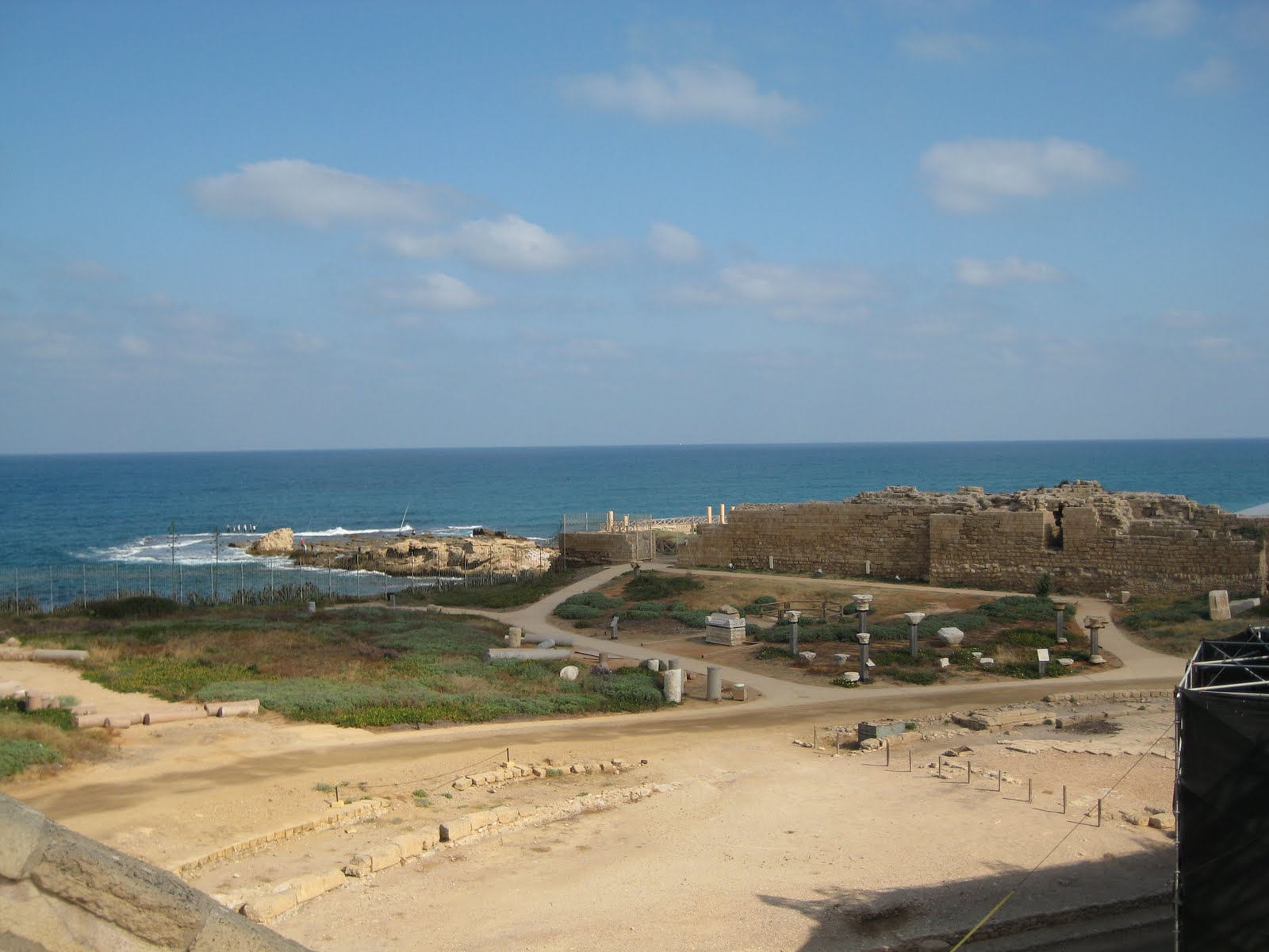
Caesarea (again)

Revisiting sites is not always a bad thing. For me, I get to learn new information each time I visited the locations. This includes the three times I’ve visited Masada, twice to Tel Dan and now twice to Caesarea. The revisit to Caesarea turned out to be a good thing for me; I got to see some new sites I didn’t have time to explore last time I visited.
King Herod also built Caesarea, but unlike Masada, which catered to both outside and inside people groups, Caesarea is a strictly Roman city built in the style of Rome.

The Amphitheatre at Caesarea
One new interesting fact I learned about Caesarea is about the amphitheatre. Usually, when building an amphitheatre the orientation is north south for lighting reasons; this orientation allows a majority of the day for lighting the state. The amphitheatre at Caesarea is oriented east west, with the stage facing the ocean. This in the ancient times was not the wisest orientation because in the mornings the sun would be in the actors eyes, and in the evening the audience would be blinded. So why did King Herod decide to orient this structure this way? The thesis is King Herod’s audience would be able to sit in awe of Herord’s building, and face Rome, a place he identified and sympathized with.
The palace at the far left
King Herod was a really interesting character. It is my opinion he was probably a narcissist. Take his palace for instance. It jutted into the sea, and featured a swimming pool not five feet from the ocean. the impression of the palace has been excavated. With his usual lavish personality, King Herod even had a fresh water pool, just feet from the ocean. Because it jutted into the ocean, those sailing into the harbor would see the palace easily, and would see Herod’s tremendous wealth and power.

View of where Herod's palace would have stood
There were also meshing of cultures at Caesarea. There are examples of pagan, Christian and other religious imagery.
As with any important site, Caesarea is layered with history from later periods as well. There is a Byzantine part of the city built by the Crusaders, as well as buildings from the Persian period.
Enjoy my pictures, and as always Happy History!

Roman sculpture outside the amphitheatre

The Bath House at Caesarea. Notice the beautiful mosaic floors

A Roman Arch (see my post on Tel Dan for a little trivia!)

An Ancient latrine

The moat dating from the Cursader time period
Tuesday, August 9, 2011
Masada Again

I found out during my third visit to Masada King Herod had wells built at the base of Masada to store even more water for his use. It was the job of his servants to go fetch fresh water to keep these wells full.
In addition to the wells at the base of Masada, there are several cisterns on top of Masada used to store water. One of these cisterns can hold one million gallons of water. With the only access to the top of Masada being the Snake Path on the eastern side (the Roman siege ramp was not yet built), servants would have to walk miles to the nearest fresh water source and then walk up a steep, windy path with water daily.

King Herod wanted to impress his visitors when they visited Masada. This was done by keeping lush green gardens at the top of Masada, and by erecting a spectacular northern palace, which had three different tiers. King Herod covered all the local stone used to construct the buildings with plaster. He then shaped and painted the plaster to look like Jerusalem rock. This would give the location a look of decadence, and his visitors would think he imported the stone from up north, adding to his perception of power.

I know I’ve already posted once from this trip on Masada, but these facts were too good to go undocumented
Thanks again to Miss Madeleine Tappy for these pictures (my camera was still dead).
Thursday, August 4, 2011
Mampsis

In the Sixth Century BCE the Nabateans, a nomadic people group, began to settle in southern Jordan, the Negev region of Israel and northern Arabia. Their capitol was Petra, earlier inhabited by the Edomites; it was the Nabateans who carved the structures into the sandstone remaining today.
The Nabateans were able to establish a trading network stretching from China, India and the Far East to western areas including Egypt, Syria, Greece and Rome. The trading routes dealt with goods including spices, incense, perfumes, fabrics and other commercial goods. This trading network was the source of power for the Nabatean Empire.
Mampsis (Mamshit), located deep in the Negev Desert, is one location built by the Nabateans. Not only were the Nabateans able to survive in this harsh location, they were ale to thrive.
Mampsis was built during the first century CE during the late Nabatean period, and was located along one of the most important branches of the Incense Route. Mampsis even appeared in the ancient mosaic floor of Madaba, Jordan, depicting Israel during the Byzantine period (4th-7th Century CE).
Mampsis was later used by the Romans after the Nabatean kingdom was annexed to Rome. Additions were made during this time, including the building of two churches. The site ceased to exist after the Persian invasion in 614 CE.
Water is important in the dry region of the Negev. The Nabateans were the only people who knew the secrets of the desert, making them the only people group able to cross the Arabian Desert. These secrets helped them maintain their monopoly on the spice trade. These secrets also helped them survive in the harsh deserts of the Middle East. Their secret to survival at Mampsis was to collect rainwater and brought it into the city through a channel system, build dams along the Mampsis stream and plaster their cisterns to preserve their water.
Mampsis is another example of the ingenuity of people living in southern Israel.
I enjoyed visiting the location, and hope the pictures highlight the sites at Mampsis!

The Marketplace in Mampsis. Both sides of the street have rooms serving as shops.

The Byzantine Bathhouse at Mampsis. This structure contained three rooms: a hot room, a tepid room and a dressing and furnace room. Similar to Masada, clay pipes along the walls allowed hot air to travel to the rooms from a furnice room below the structure.


The "Church of the Martyrs."
Tuesday, August 2, 2011
The Hamakhtesh

In southern Israel there are three large areas that have been carved out of the landscape. They are called hamakhtesh, or bowls in English. Five of the seven across the world are located in Israel.
The landscape of the hamakhtesh was carved out of the land, leaving behind only the different colors of the different levels. It is beautiful to observe.

The south is a harsh location, and it takes a keen observer to see the beauty. The colors of the landscape change each hour due to the sunlight. But in this location the colors are evident regardless of the sun. It is spectacular.
My south trip was one of my less documented trips because my camera ran out of battery. Luckily, I had a wonderful photographer, Miss Madeleine Tappy, accompanying me on this trip, and she graciously gave me her photos. I credit her with every breathtaking image included in this post. And if you like what you see, check her website out at http://myphotoscopes.com/

As a final consideration, these pictures (even with Madeline’s fantastic skills) do not do the location justice. It is something you need to see with your own eyes; I realized this is something I often do not do, instead looking through a camera monitor. Running out of batteries was actually good; it helped me see my surroundings with my eyes, instead of through a camera screen.


Subscribe to:
Comments (Atom)