Saturday, August 27, 2011

Aqueducts


The uncovered aqueduct as seen from inside the covered aqueduct

The Roman aqueducts were highly advanced and are considered by some the greatest achievement of the ancient world. Built from a combination of stone, brick and an ancient cement, these structures brought fresh water to populations, reducing disease and improving life.

Some aqueducts ran below the surface; of the around 260 miles of aqueducts only 30 miles were visible above ground. The system used gradients, making sure the water continuously flowed down, allowing gravity to do its work. For the ancient world these structures were a tremendous engineering feat!

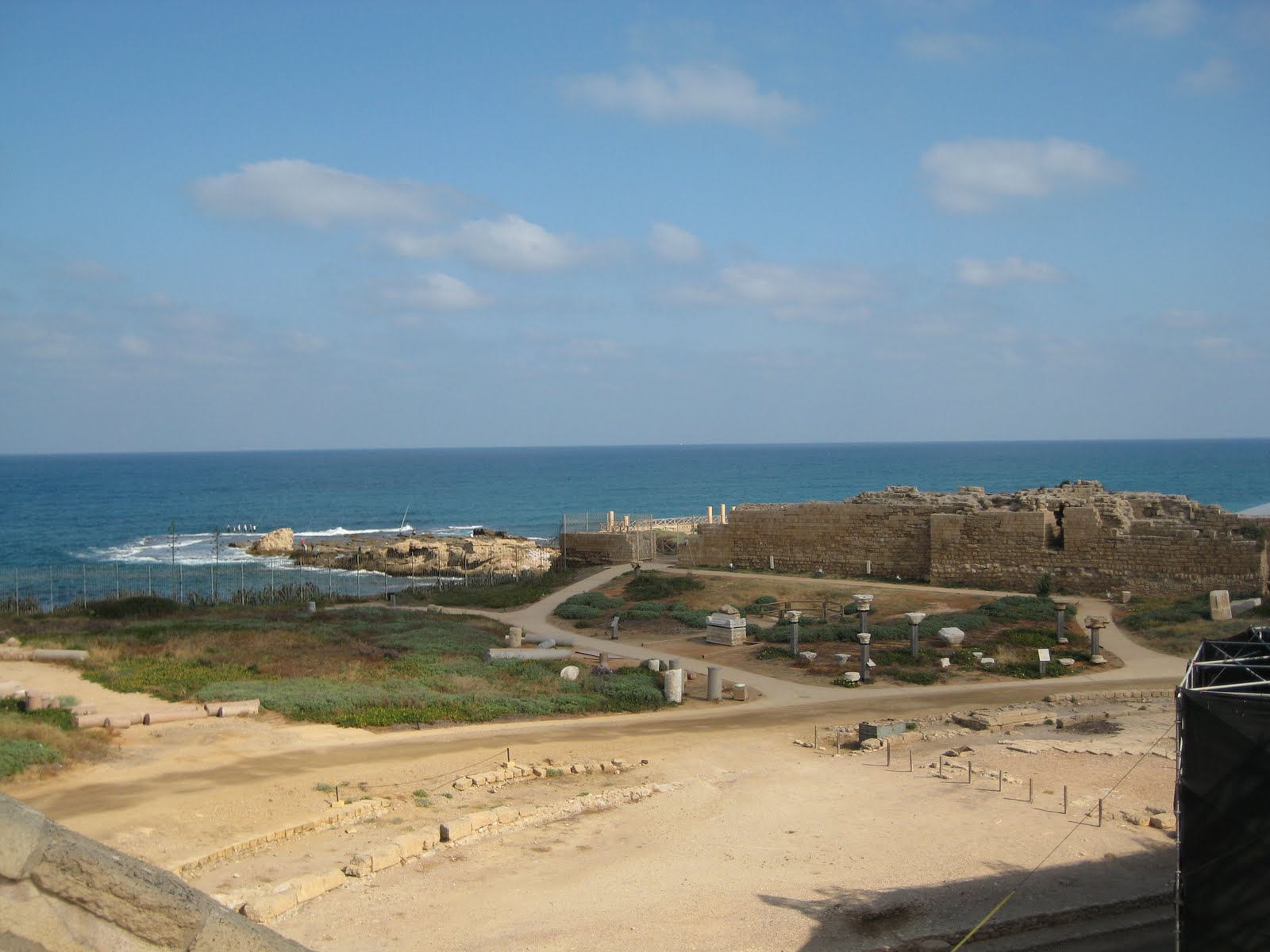
Because Israel was once part of the Roman Empire (Romans destroyed the Second Temple after revolts after all), it makes sense that they would invest in the area and place infrastructure there.

North of Caesarea the aqueducts are still visible today. There were two different lines from two different time periods. The large uncovered structure is older, and was later replaced by the covered structure.


The outside of the covered aqueducts

Here we have a clashing of time periods; aqueducts standing on both sides of a parking lot for the local beach. We had only 15 minutes to explore, and I choose to explore the covered aqueduct. The structure was close enough to the ground we were ale to climb in, and crawl through the covered area. The experience was unique and genuinely interesting.


Looking out of the aqueduct, some members of my group coming to explore


The earlier uncovered aqueduct


Both images of the inside of the aqueduct

Monday, August 15, 2011

Caesarea (again)


Revisiting sites is not always a bad thing. For me, I get to learn new information each time I visited the locations. This includes the three times I’ve visited Masada, twice to Tel Dan and now twice to Caesarea. The revisit to Caesarea turned out to be a good thing for me; I got to see some new sites I didn’t have time to explore last time I visited.

King Herod also built Caesarea, but unlike Masada, which catered to both outside and inside people groups, Caesarea is a strictly Roman city built in the style of Rome.


The Amphitheatre at Caesarea

One new interesting fact I learned about Caesarea is about the amphitheatre. Usually, when building an amphitheatre the orientation is north south for lighting reasons; this orientation allows a majority of the day for lighting the state. The amphitheatre at Caesarea is oriented east west, with the stage facing the ocean. This in the ancient times was not the wisest orientation because in the mornings the sun would be in the actors eyes, and in the evening the audience would be blinded. So why did King Herod decide to orient this structure this way? The thesis is King Herod’s audience would be able to sit in awe of Herord’s building, and face Rome, a place he identified and sympathized with.


The palace at the far left

King Herod was a really interesting character. It is my opinion he was probably a narcissist. Take his palace for instance. It jutted into the sea, and featured a swimming pool not five feet from the ocean. the impression of the palace has been excavated. With his usual lavish personality, King Herod even had a fresh water pool, just feet from the ocean. Because it jutted into the ocean, those sailing into the harbor would see the palace easily, and would see Herod’s tremendous wealth and power.


View of where Herod's palace would have stood

There were also meshing of cultures at Caesarea. There are examples of pagan, Christian and other religious imagery.

As with any important site, Caesarea is layered with history from later periods as well. There is a Byzantine part of the city built by the Crusaders, as well as buildings from the Persian period.

Enjoy my pictures, and as always Happy History!


Roman sculpture outside the amphitheatre


The Bath House at Caesarea. Notice the beautiful mosaic floors


A Roman Arch (see my post on Tel Dan for a little trivia!)


An Ancient latrine


The moat dating from the Cursader time period

Tuesday, August 9, 2011

Masada Again


I found out during my third visit to Masada King Herod had wells built at the base of Masada to store even more water for his use. It was the job of his servants to go fetch fresh water to keep these wells full.

In addition to the wells at the base of Masada, there are several cisterns on top of Masada used to store water. One of these cisterns can hold one million gallons of water. With the only access to the top of Masada being the Snake Path on the eastern side (the Roman siege ramp was not yet built), servants would have to walk miles to the nearest fresh water source and then walk up a steep, windy path with water daily.


King Herod wanted to impress his visitors when they visited Masada. This was done by keeping lush green gardens at the top of Masada, and by erecting a spectacular northern palace, which had three different tiers. King Herod covered all the local stone used to construct the buildings with plaster. He then shaped and painted the plaster to look like Jerusalem rock. This would give the location a look of decadence, and his visitors would think he imported the stone from up north, adding to his perception of power.


I know I’ve already posted once from this trip on Masada, but these facts were too good to go undocumented

Thanks again to Miss Madeleine Tappy for these pictures (my camera was still dead).

Thursday, August 4, 2011

Mampsis


In the Sixth Century BCE the Nabateans, a nomadic people group, began to settle in southern Jordan, the Negev region of Israel and northern Arabia. Their capitol was Petra, earlier inhabited by the Edomites; it was the Nabateans who carved the structures into the sandstone remaining today.

The Nabateans were able to establish a trading network stretching from China, India and the Far East to western areas including Egypt, Syria, Greece and Rome. The trading routes dealt with goods including spices, incense, perfumes, fabrics and other commercial goods. This trading network was the source of power for the Nabatean Empire.

Mampsis (Mamshit), located deep in the Negev Desert, is one location built by the Nabateans. Not only were the Nabateans able to survive in this harsh location, they were ale to thrive.

Mampsis was built during the first century CE during the late Nabatean period, and was located along one of the most important branches of the Incense Route. Mampsis even appeared in the ancient mosaic floor of Madaba, Jordan, depicting Israel during the Byzantine period (4th-7th Century CE).

Mampsis was later used by the Romans after the Nabatean kingdom was annexed to Rome. Additions were made during this time, including the building of two churches. The site ceased to exist after the Persian invasion in 614 CE.

Water is important in the dry region of the Negev. The Nabateans were the only people who knew the secrets of the desert, making them the only people group able to cross the Arabian Desert. These secrets helped them maintain their monopoly on the spice trade. These secrets also helped them survive in the harsh deserts of the Middle East. Their secret to survival at Mampsis was to collect rainwater and brought it into the city through a channel system, build dams along the Mampsis stream and plaster their cisterns to preserve their water.

Mampsis is another example of the ingenuity of people living in southern Israel.

I enjoyed visiting the location, and hope the pictures highlight the sites at Mampsis!


The Marketplace in Mampsis. Both sides of the street have rooms serving as shops.


The Byzantine Bathhouse at Mampsis. This structure contained three rooms: a hot room, a tepid room and a dressing and furnace room. Similar to Masada, clay pipes along the walls allowed hot air to travel to the rooms from a furnice room below the structure.


The "Church of the Martyrs."

Tuesday, August 2, 2011

The Hamakhtesh


In southern Israel there are three large areas that have been carved out of the landscape. They are called hamakhtesh, or bowls in English. Five of the seven across the world are located in Israel.

The landscape of the hamakhtesh was carved out of the land, leaving behind only the different colors of the different levels. It is beautiful to observe.


The south is a harsh location, and it takes a keen observer to see the beauty. The colors of the landscape change each hour due to the sunlight. But in this location the colors are evident regardless of the sun. It is spectacular.

My south trip was one of my less documented trips because my camera ran out of battery. Luckily, I had a wonderful photographer, Miss Madeleine Tappy, accompanying me on this trip, and she graciously gave me her photos. I credit her with every breathtaking image included in this post. And if you like what you see, check her website out at http://myphotoscopes.com/


As a final consideration, these pictures (even with Madeline’s fantastic skills) do not do the location justice. It is something you need to see with your own eyes; I realized this is something I often do not do, instead looking through a camera monitor. Running out of batteries was actually good; it helped me see my surroundings with my eyes, instead of through a camera screen.