Thursday, July 28, 2011

Tel Sheva and Tel Arad


Looking at the lower city of Tel Arad

The south in Israel is a dynamic region that can easily be perceived as holding no life at all. Through history people inhabiting the southern region must have possessed a certain innovation and willingness to live.

The Negev region has one of the east-west trade routes running through it, making the region important despite the climate barriers. Sites located along this path were meant to fortify the area.

Tel Sheva is a large Tel located in the western Negev and it served various administrative purposes for Judah. The site was important not only for fortification purposes, but also for military reasons.

Archeologists at Beer Sheva have uncovered some interesting finds. One is a typical four-room house along the perimeter of the site, and is the same as what I was working in at my site. This architecture is typical for Israel; three rooms go long way and are located next to each other, and the fourth room is at the back and is the length of the three other rooms. This is where animals were stored at night and during the winter, and the families would sleep in a room above on the second floor. This is important because this architecture is found across Israel (I’m excavating inside one at my site even).


The four room house

Interestingly, archeologists also found a dismantled horned altar, something associated with Jewish worship. What makes this altar different from others is the cut stone used to form the altar, something forbidden in the religion. The altar was initially found because archeologists recognized the shape of a corner horn, and then found the other scattered stones in secondary use. This would suggest the altar was dismantled, perhaps during the religious reforms of King Hezekiah or Josiah.


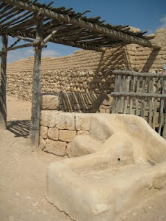
A replica of the altar (the real finds are in the Israel Museum, which I did see!)

Tel Arad is another important site for this trading route. Located east of Beer Sheva in the east Negev region, this Tel is located in the hills, providing the site with a fantastic view in the southern direction. This means those living at this site had a view of Moab and Edom, two regions not always friendly with the Israelites. Its location also made it a crucial stop for those traveling on the trading route.

Interestingly, Tel Arad has two parts to it. There is the Tel on the hill, dating from Israelite occupation and later, and there is also a lower city dating from the Bronze Age. In the harsh south of Israel, water is a crucial commodity, and ways to get the water are important to the livelihood of the population. In this lower Bronze Age city, the population collected water from the rainfall by designing their city with the well at the low point, and having the streets slope downward. This allowed runoff water to collect in the well for later use. This innovation is extremely interesting, and shows the ingenuity of the populations living in this region.


Lower Bronze Age City

Also interesting to Tel Arad is a holy site discovered there. A room dubbed the “Holy of Holies” was found with two stones shaped a bit like gravestones. The curious part of this site is that there are two stones there at all; the Israelites worshiped only one God. It has been suggested the second stone may represent God’s partner, an idea accepted in the fringe areas of Israel, areas with more lax views on religion and with Canaanite and other worldviews intermixed within the religion.


Holy of Holies at Tel Arad


Now compare the two findings at both site out of character for the Jewish religion. Tel Arad and Tel Sheva may represent two places fringe ideas are incorporated in important defensive locations. But this is interpretation, and more importantly only one interpretation of the sites.

Enjoy my pictures and as always happy history!


Tel Sheva from above looking down

The well at Tel Sheva; it is very deep (I remember 60 meters maybe) and when we threw stones down it took over 10 seconds to hear a sound.


The water system at Tel Sheva.


Gate into Tel Arad


Bronze Age well that collected water at Tel Arad


The Altar at Tel Arad. Notice these stones are not cut like at Tel Sheva.

Saturday, July 23, 2011

The Tel


I’ve been posting a lot about the travels I did in Israel while visiting Israel this summer. My post about Tel Dan concludes the trips I had with my parents, and begins the travels I had with my archeological group. But, since I was volunteering and traveling, time got away from me, and I now find myself reflecting on the trip from the United States. Just because I am back home does not mean I will stop posting about Israel; I have several other interesting sites to blog about.

But before I continue with my sites, I want to reflect on my archeological experience I had while in Israel.

Tel Zeitah is a small site located in the Shephelah or wadi system in Israel. There are several valleys located in this region; one directly to the north hosts Gath of the Philistines, and one directly south houses Lachish the Judean stronghold. This means according to Biblical literature our valley is home to Libnah, which has yet to be identified. This season we were digging in one square to reach the 8th Century BCE destruction levels corresponding to Senacarib and King Hezekiah.

Zeitah is an interesting Tel; several factors have shaped what it looks like today. Originally, the Tel was larger than it is today and the change is due to erosion escalated by human forces. Archaeological soil is very fertile, so farmers began stealing soil from the site. This man made cut, along with natural erosion, has made for a very steep eastern side to the Tel.

While most in our group worked to dig to the 8th Century, I worked with the boys and excavated in a 10th Century four room house. The square had already been excavated, so our job was to take out the bulk usually left between squares. Since this square was right next to the sharp erosion side of the Tel, our director Dr. Tappy could only hope the continuing floor survived 2,000 plus years and erosion.

Dr. Tappy’s hypothesis proved correct and we found what he hoped to find.

So what was it like to be an archaeologist? It is dirty, hot, tiring and detail oriented work. The area I worked in was especially crucial because of the information it can add to the archeological debate happening in Israel. For this reason we were told to work slowly and carefully as we worked down the bulk.

Several different levels exist in each area, and these levels can differ from inch to inch. Allow me to explain; when a home was destroyed in the 10th Century, the house was first set on fire. This would cause the roof and second floor to catch fire, since this was mainly made of wood and other organic materials. Once these burned, the wood would give way and this area would collapse in. After this, the mud brick walls sitting on the stone foundations would be left, and they would be pushed in to the floor. Now fast-forward to 2011 when my group was excavating; we would first come to the mud brick walls, but then there is a change in the make up and coloring of the dirt. Next comes the thick black soot that once was the roof of the house, and underneath there is the second level floor material, along with the first floor ceiling material. These changes occur within inches because of the way all the levels collapsed onto the floor.

I am not a natural archaeologist, but I did begin to pick up important concepts for working in the field. I was able to notice different levels in the sections, I noticed different make-ups of different surfaces, and I knew pottery like the back of my hand.

Through my experience I learned fieldwork is difficult, and may not be my strong point, but this experience has been like nothing else. I can better appreciate findings from the field, and now understand how they come to be.

Monday, July 11, 2011

Tel Dan


Jeroboam's High Place


Tel Dan has been one historical location I wanted to visit more than anything else in Israel. In my Ancient Israel class Dan was mentioned quite a bit because of its location in the country, historical importance, and the archeological evidence found at the site.

I convinced my parents Tel Dan was a worthwhile stop, and then two weeks later I visited again with my group while we were traveling north, which gave me some perspective on what I had seen before with my parents.

Ancient Dan was inhabited by the Canaanites as early as 2700 BCE. This site has been identified as the Biblical site of Laish, later captured by the tribe of Dan. Finds from the early Canaanite town include a very well preserved mud brick gate. This gate dates from the 1800 BCE include the oldest intact arch. The gate features three arches, which interestingly come much earlier than when the Romans began using arches in architecture.


Tel Dan has also has architecture dating from the divided monarch period. Tel Dan is known from the Bible as one of the places King Jeroboam of the Northern Kingdom placed one of his golden calves. The story says Jeroboam placed one in Bethel, and another in Dan to rival Jerusalem as a center for worship. Archaeological remains suggest there was a high place located at Dan.


The High Place


A four-chamber gate has also been found; it was used to fortify the city and to as a gathering place for engaging in commerce in. There is evidence of where a chair may have once stood, along with a shade canopy, a place a high official would have sat to collect goods of those coming into the town. An alter has also been found outside the gates, which suggests people could offer sacrifices before entering the city.


The Site of the Officia's Chair


The Alter

Another important archaeological find was the Tel Dan inscription. This is a stele written by King Hazael of Damascus, mentioning the House of David. This is the first outside mention of the House of David from an extra-biblical source, making it extremely important in regards to confirming history of this region.

The site of Dan lies along an ancient travel route connecting Egypt to Damascus, making the land highly contested. The site was also important for safety reasons, and also for the trade passing through the regions.

Through all my stops on this trip, I think Tel Dan is my favorite. This is not actually for the history there (that would probably qualify Masada or Jerusalem). This site is more than another pile of stones on top of a hill. The area is surrounded by a nature reserve; trees surround the archeological site, and the air is filled with a sound not often heard in Israel.

In Israel, trees are used as signals for water, so a forest would signify an excess of water. What Tel Dan has is the Dan Spring providing water to the town, and this spring is one of the five forming the Jordan River, and also the fastest flowing spring in the Middle East.


The Tel Dan Spring

Because the site is inside a nature reserve you hike in to the sites, and the various paths take you through some beautiful places. My mom and I took a wrong turn, and we walked along a path that followed the water, occasionally crossing right into it. The site is spectacular partially due to the contrast of the south where water is so scarce. The other beauty is in the physical landscape. It is honestly unlike anywhere else in Israel.


Tuesday, July 5, 2011

Trading Routes

Through history trading has been an important part of a countries economy. The international trading routes determined the relationships Israel had with the surrounding world powers. Because Israel was the overland trading route, power struggles between empires shaped how the region looked and functioned.

The typography of Israel allows for one easily accessible trading route running north-south paralleling the coast, and two major routes running east-west through the country. The placement of Israel as a connecting strip fro Egypt and Africa in the South, Damascus and Mesopotamia in the northeast and Europe in the northwest has caused these trading routes to be highly contested high friction areas through history.

The north-south trading route runs along the Coastal Plains. There were two possible paths along the Coastal Plains; one path ran along the coast, past Gaza, Ashkelon, Ashdod and Jappa before heading in east to Aphek to miss the swampy Sharon Plain. The other path ran internally more, and travelers could stop in Ekron and Lod before stopping in Aphek.

The east-west trading routes were similarly important. In the south there is a pass running through the Negev connecting southern areas with the trading powers. Those living in the southern areas, which included the Moabites and Edomites, often used this pass. Since these regions were not friends to Israel, having well fortified centers in the south was important to the security of the country in addition to the trade in the area.

The other east-west trading route located in the north is through the Jezreel and Herod Valleys to the Sea of Galilee before continuing north through the Huleh Basin. This more northern pass was extremely important for those traveling to or from Damascus and Mesopotamia. Because of the military strength of these areas, well-fortified centers were also crucial to this region.

Trade is important historically; countries were interconnected and traded with one another. The ways people got from one location to another has always been important, and the desire to control trading traffic can cause conflict.

This was not a blog I intended to do initially. I started writing one about Tel Dan, but soon realized it, along with several other locations I’ve visited, is located on the ancient travel routes. Tel Dan's location is crucial to its historical story, and I can now go on to explain the interesting specific facts about the location.